

Staying safe outdoors is a skill that all hikers and backpackers should learn, like wearing suitable clothing, navigating unfamiliar terrain, and assessing risk in changing conditions. But some places are dangerous, no matter how experienced you are. We have listed some of the most dangerous hikes in the U.S.
1. ANGEL’S LANDING, ZION NATIONAL PARK
Angels Landing is one of the most popular destinations in Zion National Park. Many who go there want to experience an untamed adventure and take a classic photo. The trek is strenuous but also serene. The first 4km of the trail is accessible to people of all skill levels.
The last half mile to the summit features narrow lanes. However, the park service has installed chains along the trail to help hikers on this hair-raising stretch; still, Angels Landing remains one of the most dangerous hikes many hikers will undertake. Angels Landing requires a permit to climb to the top
2. CAPITOL PEAK VIA THE KNIFE-EDGE, COLORADO
Capitol Peak in the Elk Range near Aspen is one of Colorado’s most radical 14’s hiking opportunities. Seen from afar, it is a classic mountain dominating the horizon.
But it is also one of the country’s most exposed and deadliest peaks. The Elk Range features some of the state’s highest, most beautiful, and most challenging mountains. A few decades ago, few people attempted Capitol Peak each year; In 2017, it claimed five lives in just six weeks.
The infamous section of the hike is Knife Ridge, a 150-foot razor-sharp blade of granite rock with a drop of more than 1,000 feet on either side. This section is not for the inexperienced ones. One wrong move could send visitors to their deaths.
Experienced climbers can manually traverse the section to the left of the ridge, while other climbers traverse the ridge by putting one leg on each side and sliding.
From the Capitol Creek Trailhead, this hike is 17 miles and has an elevation gain of 5,300 feet. So many choose to complete it in two days. It would help if you had hiking, rock climbing, and rock climbing experience to safely complete the trek.
3. MIST TRAIL AND HALF DOME CABLES, YOSEMITE NATIONAL PARK
Half Dome is one of the most recognizable landforms in Yosemite and all national parks. Yosemite permits 300 visitors to flock to this massive granite mass daily, but only 50 are allowed onto the steep, domed backside. The park service installed steel cables and wooden planks along the last 400 feet of the climb.
The ladder is screwed into the rock to help hikers, but it doesn’t make the trail completely safe. It makes it one of the most dangerous hikes in the U.S. Also, beware of storms – the rock becomes very slippery and dangerous when it rains. The Half Dome cables aren’t the only tricky part of this hike.
The Mist Trail hiked en route to Half Dome is also possibly one of the most dangerous hikes in the U.S., with more than 14 deaths in the last ten years.
Along the way, hikers will also pass the legendary Vernal and Nevada Falls, some of the most beautiful waterfalls in the world. Unfortunately, despite signs and railings warning visitors to stay away from the water above the falls, dozens of lives were claimed.
While most visitors know better than to swim over a waterfall, some hikers still slip over the railing for a quick peek or photo. The slippery granite makes it easy to fall into rushing water and be gone instantly. When hiking the Mist Trail in Yosemite, respect the barriers, don’t swim over the falls, and look for storms when approaching the Dome Half Cables.
4. HUCKLEBERRY TRAIL, GLACIER NATIONAL PARK
Glacier National Park is home to the highest population density of grizzly bears in the lower 48 states, so backpackers must take many precautions to stay safe. A recent study found one bear for every three square miles of the park, or about 563 bears. However, some wildlife biologists consider this estimate to be low.
Bears come to eat the high-calorie fruit that grows along the trails on the slopes of the peak. Bears love this place so much; however, it is not uncommon for backpackers to encounter a bear on this trail.
5. CAMP MUIR, MOUNT RAINIER NATIONAL PARK
This 9-mile (14.5 km) loop hike to Camp Muir in Mount Rainier starts harmlessly. It begins on the Skyline Trail, where you can enjoy a variety of colorful wildflowers for 2.3 miles. Then, after some climbing, you will reach the Muir Snowfield. Although this section isn’t precisely a glacier, it holds snow all year round.
From here, you’ll have to navigate 2.2 miles – and more than 2,900 vertical feet – of an unmarked route across the vast white expanse. If you stay in the snow field, you should be safe. But if you go too far left or right, you’ll encounter crevasses and cliffs from the surrounding glaciers. Unpredictable storms can sweep the Pacific Ocean and blanket the snowfield in dense fog.
These conditions confuse even the most experienced hikers in the height of summer. So be prepared with crampons, an ice ax, appropriate clothing, and a first aid kit. More than 90 hikers have died on their way down this route, with 294 deaths on the mountain.
6. CHINITNA BAY, LAKE CLARK NATIONAL PARK, ALASKA
If you’ve ever thought of hiking in an area with many grizzly bears, then Chinitna Bay in Alaska’s Lake Clark National Park is the place for you. Unlike other popular Alaskan bear viewing areas. You are allowed to backpack in this dense bear area.
The National Park Service has noted that up to twenty grizzly bears were in one location at a time. If you want to hike here with the Backpack, the 25-mile backcountry hike from Chinitna Bay to Silver Salmon Creek is your best bet.
This hike is impressive, especially if you visit in late summer to early autumn when grizzly bears are gorging on fresh salmon in the Wadden Sea. Remember to pack a bear canister and spray, and read up on tips for traveling in grizzly bear country.
7. BARR TRAIL, PIKES PEAK, COLORADO
Colorado is known for its afternoon thunderstorms. So it should be no surprise that Colorado’s tallest mountain, Pikes Peak (14,115 feet), is a bevy of lightning and electrical activity. It makes the Barr Mountain Trail particularly dangerous.
The Popular route with 13 miles of elevation gain of 13 miles through terrain mainly above the tree line. Local conditions like mountain altitude, regional air currents, and winds from the plain practically invite thunderstorms.
Colorado leads in lightning deaths, and El Paso is one of the hardest-hit since most of the trail is above the tree line; visitors must plan accordingly and disembark when necessary to avoid dangerous situations.
8. JACK MOUNTAIN, NORTH CASCADES NATIONAL PARK, WASHINGTON
A little-known fact: North Cascades National Park has a much higher chance of dying than any other national park. Despite its wild and rugged nature and proximity to Seattle, it’s one of the least-visited parks in the Lower 48. Capita is 652 per 10 million visitors, almost 22 times the average.
Jack Mountain has a standard route that climbs the south face and has great difficulty, loose rock, and year-round snow potential. It would be best if you had the right equipment and alpine experience to tackle this challenging route. Not only is the trek highly technical, but you must adapt to rapid weather changes and difficult navigation.
9. PRESIDENTIAL TRAVERSE, NEW HAMPSHIRE
This 20.4-mile hike traverses some of the highest mountains in New Hampshire. On the peaks, Mount Washington is the highest peak in the Northeast and has the worst weather on earth for real. It once recorded 231 miles per hour wind speeds, the current record for the highest wind speed on land (not linked to a hurricane). Mount Washington also receives a lot of rainfall.
The White Mountains offer some of the most dangerous hiking in the United States as weather conditions can change quickly. It is not uncommon for a sunny 70-degree summer day to turn into a windy and humid 40-degree day.
10. DENALI, DENALI NATIONAL PARK, ALASKA
Alaska is known for its rugged and highly remote terrain, which is home to more large mammals than humans. It is also home to Denali (formerly known as Mount McKinley), which at 20,194 feet is the tallest mountain in North America.
It’s the third most remote peak in the world, and climbing its snow-capped mountain is not for novice hikers or casual tourists. This is not considered a “hike” but rather a mountaineering effort.
Brave solid winds and freezing conditions, traverse glaciers, chance encounters with black and grizzly bears, and battle the effects of altitude sickness in a highly remote area.
You must train for this hike to be physically fit and get used to the high altitudes. Only about 50% of hikers successfully reach the summit, and the mountain has claimed more than 100 lives in the last century.
How to stay safe: Satellite Phone
Satellite Phone For Hiking: Many hikes will put you out of cellular range, which means you won’t be able to stay in contact if something goes wrong. Having a satellite phone will keep you safe, and you can even rent one if you only need one temporarily.
Be sure to have a backup battery for any electronic devices you take.
Best Satellite Phone For Hiking
ICOM IC SAT100 PTT Satellite Radio
Satellite communication is an increasingly popular option for users that wish to stay connected regardless of the quality of service in the surroundings. But, the kind of satellite radio product you choose will impact your experience in the long term, and for this reason, ICOM IC SAT100 PTT Satellite Radio is one of the best options in the market.
The satellite radio communication device provides the ultimate land mobile radio experience to help users stay connected through all the situations.
The radio communication device also has IP67-rated durable housing and a front speaker for loud voice and output. There’s a volume selection button on the device. The users also get an on and off option on top of the device.
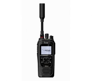

Buyers also get a talk group selector that allows using the device without looking at it. It makes the ICOM IC SAT100 PTT Satellite Radio a quick and handy solution to stay connected even in a tight situation.
The ICOM also develops and offers many accessories and enhancements to make the satellite radios more accessible. The device utilizes the Iridium Push-To-Talk services to operate, which allows it to work seamlessly with Iridium and Iridium Partner PTT products.
The availability of many products, global push to talk options, and much more make the ICOM IC SAT100 PTT ideal for your next satellite communication device.
The device also comes with a VE-PG4, a RoIP router, allowing users to interconnect with other radios and efficiently manage their latency. There’s a 100% global coverage guarantee with the IC-Sat 100 PTT satellite network. It also allows users to contact and communicate with all radios with a button to make communication easier and quicker.